


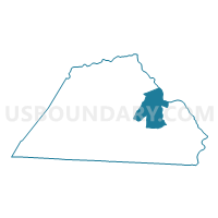
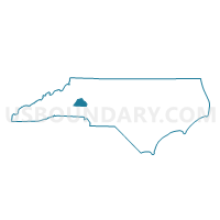
Voting District 05, Catawba County, North Carolina
About
Outline

Summary
| Unique Area Identifier | 639632 |
| Name | Voting District 05 |
| County | Catawba County |
| State | North Carolina |
| Area (square miles) | 23.81 |
| Land Area (square miles) | 23.40 |
| Water Area (square miles) | 0.41 |
| % of Land Area | 98.27 |
| % of Water Area | 1.73 |
| Latitude of the Internal Point | 35.68878830 |
| Longtitude of the Internal Point | -81.09584670 |
Maps

Graphs
Select a template below for downloading or customizing gragh for Voting District 05, Catawba County, North Carolina


Neighbors
Neighoring Voting District (by Name) Neighboring Voting District on the Map
- Voting District 01, Catawba County, NC
- Voting District 06, Catawba County, NC
- Voting District 21, Catawba County, NC
- Voting District 22, Catawba County, NC
- Voting District 27, Catawba County, NC
- Voting District 31, Catawba County, NC
- Voting District SH-A, Iredell County, NC
- Voting District SH-B, Iredell County, NC
Top 10 Neighboring County Subdivision (by Population) Neighboring County Subdivision on the Map
- Newton township, Catawba County, NC (32,264)
- Clines township, Catawba County, NC (24,354)
- Mountain Creek township, Catawba County, NC (9,678)
- Shiloh township, Iredell County, NC (8,705)
- Catawba township, Catawba County, NC (8,490)
- Caldwell township, Catawba County, NC (7,722)
Top 10 Neighboring Place (by Population) Neighboring Place on the Map
Top 10 Neighboring Unified School District (by Population) Neighboring Unified School District on the Map
Top 10 Neighboring State Legislative District Lower Chamber (by Population) Neighboring State Legislative District Lower Chamber on the Map
Top 10 Neighboring State Legislative District Upper Chamber (by Population) Neighboring State Legislative District Upper Chamber on the Map
Top 10 Neighboring 111th Congressional District (by Population) Neighboring 111th Congressional District on the Map
Top 10 Neighboring Census Tract (by Population) Neighboring Census Tract on the Map
- Census Tract 113, Catawba County, NC (7,187)
- Census Tract 101.01, Catawba County, NC (6,112)
- Census Tract 115.01, Catawba County, NC (4,821)
- Census Tract 101.02, Catawba County, NC (4,057)
- Census Tract 114.02, Catawba County, NC (4,030)
- Census Tract 115.03, Catawba County, NC (3,715)
- Census Tract 114.01, Catawba County, NC (3,525)
- Census Tract 611.03, Iredell County, NC (2,769)
- Census Tract 611.01, Iredell County, NC (2,668)
Top 10 Neighboring 5-Digit ZIP Code Tabulation Area (by Population) Neighboring 5-Digit ZIP Code Tabulation Area on the Map
- 28625, NC (36,189)
- 28677, NC (32,940)
- 28658, NC (27,022)
- 28613, NC (22,759)
- 28610, NC (9,913)
- 28609, NC (5,864)